Showing posts with label Split Rock Lighthouse. Show all posts

Thursday, June 26, 2014

Split Rock LIghthouse Tour, June 16th, 2014


Joe and I are spending more weekends in St. Cloud than we are on the North Shore this summer. This is 100% due to the upcoming wedding, move, and job search. So, on the few weekends we are up here, we’ve been checking some items off of the North Shore Bucket List. On June 16th, after living up here for three years, we finally went to Split Rock Lighthouse State Park for the Lighthouse tour. 


Hello Lighthouse

I KNOW! It’s hard to believe, but we’ve never actually taken the Lighthouse Tour. The day was cold, windy and rainy but we were determined. 42 degrees at 4pm? Pshaw! 45 mph winds off Lake Superior? A mere breeze! We were tourists and we were going to learn about the Split Rock Lighthouse, darnit.  Although the Lighthouse is within the boundaries of the state park, the Lighthouse itself is run by the Minnesota Historical Society.


Welcome to summer on the North Shore

We took the 20-minute guided tour, which met outdoors. There were people from all over the country – and world! – in our group. There was a couple from Florida, people from India, people from the East Coast…all of them bundled up and probably what the heck they were thinking with a trip to the North Shore of Minnesota in June.

 
BWWWWAHHHHHHHHHHH

We checked out the Foghorn house, and listened to the foghorn. The foghorn and the light station were put in after the deadly 1905 storm in which 29 ships were dashed upon the shore on a single day. For decades, there was no road up to the lighthouse so the Lighthouse Keepers had to boat in and live on site with their families. There were three Lighthouse Keepers, and they lived in three identical houses on site. They each worked eight-hour shifts, and when there was need for the foghorn there needed to be a Keeper in the Lighthouse AND in the Foghorn house. 

 
Rocky shore, upon which many a seafaring boat has crashed


The geology of the North Shore added an extra level of necessity for the Lighthouse: there is so much iron ore in the rocks that compasses are not reliable. Joe and I noticed this when we were driving up around the Vermillion Range last summer: the compass in his car was going nuts. Can you imagine being on the lake, knowing that there is a rocky shoreline nearby, and your compass is spinning wildly? Thank goodness there’s a Lighthouse!


Joe on the stairs

The Lighthouse itself isn’t all that tall, because it’s up on such a high and exposed point of land. Joe and I headed up the narrow stairs to see what the lens looked like. They keep it rotating, but they only light it once a year nowadays: on November 10th, the anniversary of the wreck of the Edmund Fitzgerald.  The Lighthouse was in operation from 1910 to 1969, and then was re-opened as a Historic Site in 1971.  

 
Here I come, buddy!  No more loneliness for Homer and E.A.R.L.!

That is one helluva lens. Right now there is a 1,000 watt lightbulb…much easier to care for than the kerosene lantern that used to light the way. The Lighthouse Keepers had to constantly scrub the glass to keep it clean from soot and residue.  The beam can be seen sixty miles away on a clear night, but it's those not-so-clear-nights in which you want to see the light in the darkness.

I wonder what life would have been like as a Lighthouse Keeper. I probably would have gone nuts, Jack Torrance style. But was great to finally get out there and see the inside of the Lighthouse and the grounds, ticking that box on the North Shore Bucket List.

Mr. and Ms. Lighthouse Keepers, at your service

Monday, July 22, 2013

Split Rock Loop, July 21st 2013

Our friends Mandy and Mark (previously highlighted on the Dogsled Trip posts) were up on the North Shore for a mini-holiday last weekend, so we decided to go for a hike!   They suggested Split Rock Loop, and I thought that was a great idea.  We each packed part of a picnic lunch and set out around 11am on Sunday morning.


Mark scrubs off his boots at the boot scrubbing station.  Gotta get those tansy seeds off!

After much thought, we decided to leave Thunderdog home for this hike.  She was practically eaten alive by blackflies during the week, and I worried that it would be a buggy hike again on Sunday.  I shouldn't have worried.  None of us even had to bother with bug spray due to the cool breeze blowing off the lake.  I felt kinda bad about leaving her behind.  I will have to make it up to her.


We passed the same little waterfall that we saw on May 15th: no fish jumping this time, though.

We stopped at the trail register right after the pretty waterfall, and signed it.

Mandy, Mark, Michele and Joe
a hiking, a hiking, a hiking we go


Amazing (but a bit blown out) picture of Split Rock River

Mandy and Mark at the Split Rocks - hence, Split Rock River

We arrived at the halfway point and were ready for lunch.  Before we sat down on the rocks and got out the picnic, we risked our lives by several of us walking onto the bridge at once.  Seriously though - this bridge has a heckuva lean.  There are a couple of cables holding onto it, but that is not a trick of the camera: it really is bowing very noticeably to the left.  It's only six years old...we wondered why it was in such rough shape.  I thought that perhaps it was damaged in the flood last year, but it is bowing upriver.  Do as the sign says, not as we do, kids!!


Noooooooo we are going to die!!

We sat down to enjoy our picnic: peanut butter sandwiches, homemade cookies, apples, cheese sticks, and I brought a can of Pringles.  I am not a huge Pringles eater, but they seemed like a good salty snack in a semi-sturdy container.  It was a great lunch.


Welcome to Idyllic Picnic Town, MN.  Population: us.

Until...disaster.  For no good reason, the Pringles can popped out of my hands and tumbled down the rocks.  Past my outstretched fingers, just out of Joe's reach...and into the river.  Noooooo!!!!  I didn't want to litter, so I immediately leapt up and ran downriver in the hopes of stepping out on some rocks and catching it with a large stick.

This didn't work.  I fell flat on my ass, right in the river.


Dramatic reenactment with minor photoshopping for effect

Obviously, I missed the Pringles can.  While I was standing up to deal with the fact that I was now soaking wet from both feet all the way up my left side to my head, the Pringles can bobbed merrily downstream.  I was a litterbug.  A sopping wet litterbug.


They should revoke my Hiking Club patches and my Superior Hiking Trail Association membership.

It didn't ruin our day, though.  The second half of the Split Rock Loop is easier than the first half (if you start from the roadside trailhead, not in the State Park proper), and it really was one of those amazing North Shore afternoons that makes the long winters worth it.  We laughed and chatted and at one point I found a piece of bark that looked exactly like the state of Minnesota.


On par with the Jesus Toast or the Elvis Potato Chip!

It was great to see Mandy and Mark again.  Good hike, beautiful day, good friends.  We're going to see them again in about three weeks for a Hiking Club Trail hike and then some board games.  They're the ones that actually got me interested in Hiking Club Trails - I think they're still ahead of Joe and I, but we're catching up!

And, of course, there's the Superior Hiking Trail.  I had a wonderful time, despite fall on my butt in the river and having to walk with squishy shoes for the rest of the hike.


Total miles hiked today: 5.0
Total miles hiked in 2013: 68.3
Total Superior Hiking Trail miles hiked in 2013: 17.9
Total ticks today: 0
Total ticks in 2013: 54

Thursday, May 16, 2013

Superior Hiking Trail, Split Rock Loop: May 15th, 2013

Minnesota continues to dry out and heat up, but of course the North Shore is behind the rest of the state in both categories.  It was 96 degrees out in the Cities on Tuesday...and it was in the mid-50's up here.  We still have snow and ice further up north and inland, but around here there's just little pockets of snow under trees and in hidden ditches.  Yesterday the temps soared into the low 70's, the sun shone, and it was time to take a Wednesday Wander.  I saw from the Superior Hiking Trail Association's Facebook page that the Split Rock Loop was dry...so off we went!


Off we go!

The weather was glorious, but the forest is definitely greening from the bottom on up.  There's some ground cover, but not much in the way of flowers or leaves on the trees.  Thanks to this we had some great views, but I also wound up with a little sunburn from the lack of shade.


Blue skies, no leaves yet

There was quite a bit of early Spring wildlife out there.  Some of the highlights were several kinds of butterflies (Spring Azure, Red Admiral, and a few that were too far away to identify), a garter snake that squiggled across our path, dragonflies, and lots of ants marching around.  We also came across a dead deer - Thunderdog was very interested - and we stopped to watch trout trying to jump up a small waterfall, which did not interest Thunderdog at all.


How do trout get upstream with waterfalls?

Thunderdog and I did the Split Rock Loop last year...on April 4th!  I'm pretty sure that we were out there not long after snowmelt in 2012...it's amazing how much longer it took for the trail to be hike-able this year.  We signed the Trail Register again and huffed and puffed on the steep inclines again.  I'm a bit worried about our upcoming trip to Colorado...will I be able to handle mountains, if I get winded by little old Split Rock??  I think that there were several factors at play.  It was the first warm day of the year, it was the first big hike of the year, and there IS a lot of up-and-down.  Thunderdog was also feeling the heat...luckily, we found a patch of snow hidden in a shadowy spot.  She immediately flung herself onto her beloved snow and rolled around for a while.


Thunderdog LOVES snow, and this will probably be the last of it for the year

The Split Rock Loop is five miles long.  The first half of it (from the trailhead to the bridge) is more difficult than the second half.  The first half follows the river pretty closely - lots of up and down, lots of listening to the roar of the water - but the second half veers away from the river and goes through the woods.  The path levels out a bit and, after a while, I couldn't even hear the river.  Instead, I heard the tweeting of birds, singing of Spring Peeper frogs, and maybe the drumming of a Ruffed Grouse.

And the smell!  The smell of spring and summer on the North Shore is so distinctive, so heavenly...I wish I could bottle it and keep it year round.  It's a strange mixture of pine needles that have been heated by the sun and the bacteria emanating from the leaves and dirt that are thawing out in the warm weather.  It's sort of a spicy, earthy smell.  Believe me, "Spicy Bacteria Smell" doesn't SOUND that great, but to me it's a smell that takes me back to childhood summers and warm nights in the woods.


Self portrait with the rocks, pines, and river

One more note: yesterday was Thunderdog's fifth birthday.  She (and her littermates, and mom-dog) were found in the woods near Bemidji when the pups were about two days old.  They were all taken to the Beltrami County Humane Society.  I went up to visit when the pups were about 7 weeks old, picked out my favorite, put in a deposit, and went home to wait for my pup to be old enough to take home.  When I returned to get my pup, I discovered that the Humane Society had given her to somebody else!  I was devastated.  They said, "Well, there's one puppy left from the litter, we'll give her to you for free if you want."  I was worried that it would be a bad idea to bring a different puppy home when I was mourning the one that was given away, but I took the puppy anyway.

Best decision I ever made.   Fate stepped in and - while I'm sure that the pup I was supposed to get would have been an awesome dog too - I wound up with the one that I was supposed to spend my time with.  I love ya, Thunderdog!


Five mile hike on her fifth birthday!

We never see pictures of me and Thunderdog together, probably because either I'm holding the camera or I'm holding her...or both.  Well, here's a self-portrait that she photobombed: probably just one of a handful of pictures of the two of us.


Total miles hiked today: 5
Total miles hiked in 2013: 13.2
Total Superior Hiking Trail miles hiked in 2013: 6.8
Total ticks today: 0
Total ticks in 2013: 2  (I found two last week, a few hours after putting up the post)

Sunday, July 29, 2012

Split Rock Lighthouse State Park AND Superior Hiking Trail: July 24, 2012

Well!  Thunderdog and I had such a fine time at Split Rock Lighthouse State Park with Joe a few weeks ago that we decided to go back on Tuesday.  We didn't want to do the Hiking Club Trail again - there were more things to see!  So when I stopped at the Ranger Station, I spoke with the staffer on duty (who I actually know from work!) and we worked out an interesting 4.1 mile hike that would give a good overview of everything Split Rock has to offer.  Except, of course, for the Lighthouse.  One of these days I'll get there.

Gitchi-Gami trail again!  We hardly had time to miss it.

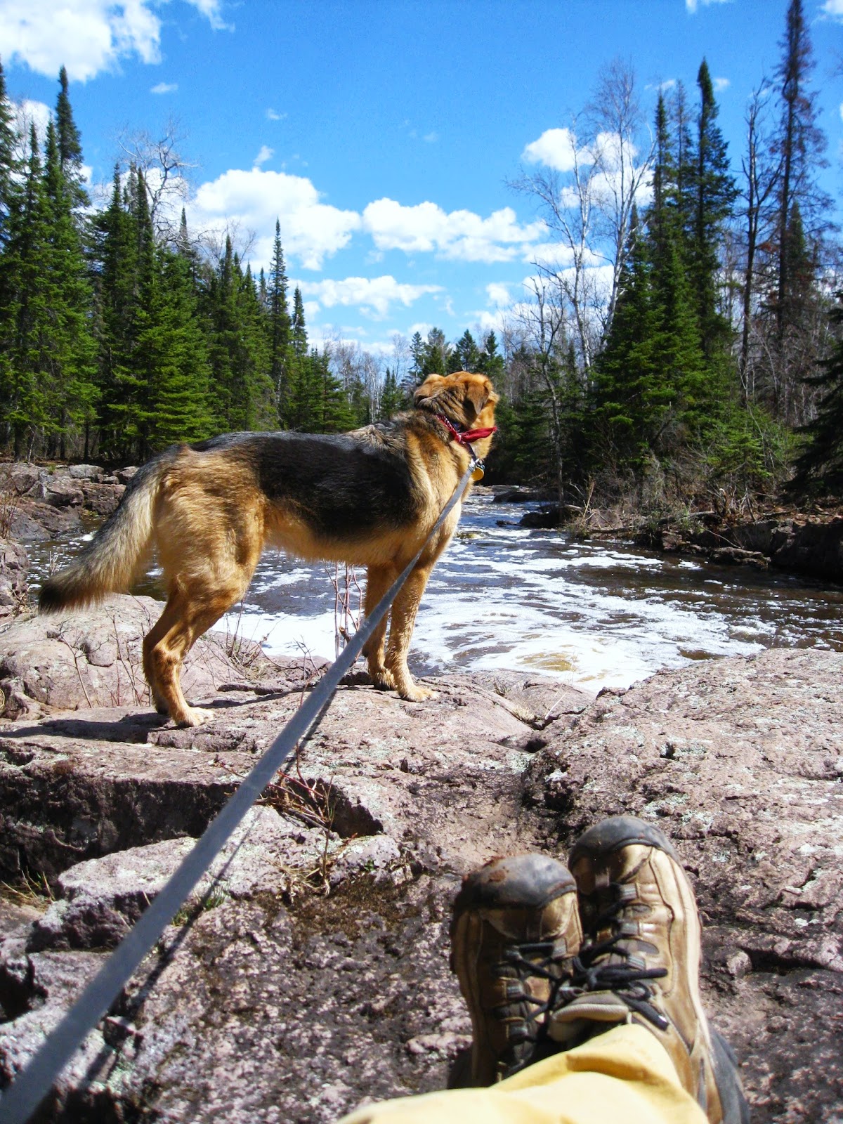
We started out on a familiar path: the Gitchi-Gami state trail.  It was a beautiful day (of course): not too hot, a little breeze coming off the lake, blue skies.  We moved along at a pretty good clip.  We then turned north on a spur, that required us to run across Highway 61.

When we got to the other side of the highway, we saw a very scary looking sign.  I wish to all of the gods that I'd gotten a picture of it.  It was along the lines of

DANGER DANGER DANGER 
BRIDGE OUT AHEAD 
OH THE HUMANITY 
DISASTER AHEAD 
GO NO FURTHER IF YOU VALUE YOUR LIFE 
ABANDON HOPE ALL YE WHO TRY TO CROSS

Apparently, there was a bridge ahead that had been washed out (probably in the flood last month).  Well, Thunderdog and I are particularly hardy folk, so we decided to go for it.  I looked at the map, and deduced that even if we had to turn back 1/10 of a mile from the end of the trail, we'd be okay.  So we kept going and soon hooked up with the Superior Hiking Trail.


Superior Hiking Trail sign, with the signature lean

The trail was a bit overgrown - clearly, most hikers had decided to heed the stern warning.  Other than being kind of grassy, it was in good shape.  No standing water, no groundhogs, nothing to keep us from having a good time.  Thunderdog really appeared to be enjoying herself.  And then, suddenly, we came upon the washed-out bridge.  Danger!  Horror!  Mayhem!


YOU SHALL NOT PASS!!!!

Right.  So, it really was washed out.  There were pieces of bridge a good 20 feet away from where it used to be attached to the banks of the creek.  But the creek was so low that it was stagnant in parts, and we were able to cross it without even getting our feet wet.  Of course, even though Thunderdog WOULD have been able to cross without getting her paws wet, she splashed around and enjoyed making a mess of herself.


Kind of overgrown trail through the woods

The difference between the park-maintained trails and the SHT-maintained trails is pretty staggering.  The park trails are about six feet across and mowed.  The SHT trails are about 16 inches across and just a worn footpath.  Some places are kind of treacherous - clinging to the edges of cliffs, or vertical trails up hills of big and wobbly rocks.  The more I hike, the more I realize that I like the SHT style trails much better.  For example, a six foot wide mowed trail would not have worked in a place like this:


Thunderdog on the hillside

I find that nothing makes me feel on top of the world like BEING on top of the world.  Standing on a small, well-worn trail that looks out miles over the land and sea, breathing in the hot piney air spiked with wildflower dust, listening to cicadas and birds and the rustle of needles and leaves.  There's nothing like it.  


They should have sent a poet!

We eventually came to the intersection in which we could have either stayed on the SHT (and hopped onto the Split Rock Loop, which we'd done already) or headed back down to the State Park.  It was getting a bit late, so we said farewell to the ridge and headed back to the highway.  Once we were back on the Gichi-Gami trail, though, we found something almost as sweet as a long view over Lake Superior.


Delicacies on the trailside - raspberry bushes galore

Oh man, there were so many raspberries.  I wasn't sure if it was okay to pick them (you can't pick wildflowers in State Parks), but after grazing on them as we walked I decided that it was really better for the park if I just picked one cups-worth of them total (and put them in a bag) rather than try to eat weight in them as I walked along.  :-)  The only container I had (other than my hand or stomach) was one of Thunderdog's poo bags.  That worked pretty well, except that the raspberries got all smushed together in the bag.  No worries.  I had plans for them that required smushing anyway.


Thunderdog at the fireplace

Our path took us up Day Hill to the mysterious fireplace up top.  Nobody knows who built the fireplace.  Most likely it was built within the last 100 years or so by some eccentric or scouting troop, but I prefer to believe that it was built centuries ago.  Isn't it romantic to imagine a group of people building the fireplace to create a lighthouse so that those in boats on the lake wouldn't crash into the shore?  Thunderdog didn't care about any fireplace theory, she was about ready to go home.


Split Rock Lighthouse from Day Hill

All in all, we hiked a wonderful 4.1 miles.  It took quite a long time because I spent a long time gazing out over Lake Superior and picking berries.  That little taste of the Superior Hiking Trail did me good, though - next week I will definitely be looking for an SHT mid-week trip.  Joe and I are still plugging along on the State Parks, those will continue to be our weekend hikes - until we run out of parks, of course.


Fresh raspberries, smushed and ready for eating...

...with my favorite kind of ice cream: natural vanilla bean.  Yum.

Total miles hiked today: 4.1
Total miles hiked (in 2012): 92.8

Total ticks today: Joe - 0; Thunderdog - n/a; Elly - 0
Total ticks (in 2012): 48

Monday, July 16, 2012

Split Rock Lighthouse State Park AND Superior Hiking Trail: July 15, 2012

It is only proper that I, as a citizen of the North Shore of Minnesota, should visit Split Rock Lighthouse State Park at least once during my time here.  Although the lighthouse is a symbol of the North Shore.  After the big storm of 1905, the lighthouse was built to help guide ships over the rocky area by Lake Superior.  There are huge ore deposits along the lakeshore - there are so many that the magnetism actually interferes with compass use.  Therefore, lighthouses on the North Shore are both beautiful and functional.

Confession time:  I have actually never been to the lighthouse itself (for SHAME Elly!!) but I have done the Hiking Club trail several times.  Therefore, I knew in advance that there was a long stretch of paved path on the 5.8 mile Hiking Club Trail, the path went down by the lake (for Thunderdog to drink and cool off in), and there was a straight-from-hell flight of stairs at the end.  Sunday was another hot day, but it wasn't nearly as hot as our St. Croix State Park trip.  We decided to go for it.


Thunderdog saves a stick from the water, lighthouse in the background on the left, Ellingson Island on the right

Almost immediately we knew that it would be a good hike.  Even though it was warm, the cool breeze from the lake helped to cool us off.  The blazing sun of St. Croix was hidden behind a persistent haze.  Thunderdog did drink her fair share of water on the trail, but never got to the "What the hell are you putting me through???" point.  It was great.

The Hiking Club trail first takes hikers to the fantastic natural harbor created by the point upon which the lighthouse stands and Ellingson Island.  Ellingson Island is attached to the mainland by a seasonal isthmus, and it is possible to go out there and explore.  Joe and I have done that in the past, but we skipped it this time.  Odds are it would have been impossible anyway - there are several months out of the year in which the island is off-limits so that the nesting birds can do their thing without being bothered by exploring humans and dogs.  Thunderdog had plenty of fun playing in the water, rescuing sticks.


Strolling strolling strolling

Once done with the scenic bay, the Hiking Club Trail meets up with the Gitchi-Gami trail and heads down the shore.  It was a pleasant walk: not too hot, enough trees to shade the path a bit, we moved along at a good clip.  My only gripe about the trail is that it is not always easy for dogwalkers and bikers to share the trail.  As you can see from the picture above, Thunderdog has this habit of walking on the opposite side of the road as whoever has the end of her leash.  I wonder if it's a teenage dog thing? Whatever the reason, we wind up reining her in quickly when bikers come by.  It's hard being so uncool that your teenage dog won't walk next to you.


Hooray, water!

At the far end of the trail we found a little path that took us to the lakeshore.  Thunderdog splashed around a bit next to some old pilings by the mouth of the Split Rock River.  After she'd had enough to drink, we continued on our way.  We passed some beautiful wildflowers that I had not seen yet that year - I named them Blazing Daisies.  Here is a picture of one in the shadow of Joe's head.

Playing tonight: Flowerhead Joe and the Blazing Daisies

I probably spent too much time talking about the evil flight of stairs at the end of the trail.  I remember coming across them last year: no warning in my guidebook, nothing on the map, 114 steep wooden steps right at the end of a 5.8 mile trail.  Be warned, my readers!  The toughest part of the trail comes at the end.  It was much easier for me to climb up them than it was last year, but we were all winded at the top.  Well, some less than others.  Thunderdog didn't mind the climb, and was particularly smug about it at times.

Hurry up, slowpokes.  I'm just sitting here waiting for you.

Back at the bay, we discovered that some rockstackers had been at work.  Oh, you all know that I love rock stacks.  Remember how happy I was when I saw them at Temperance...and how mad I was when I realized they were fake?  Well, these rockstacks were the proper sort: impromptu, amateur cairns that would soon either get knocked, blown, or washed over by waves.  A fine counterpoint to the Split Rock Lighthouse, which has survived wind and rain for over 100 years and is still guiding ships (and attracting tourists).


I should also mention that several miles of the Hiking Club Trail are also a Superior Hiking Trail spur.  I am not sure of the exact distance - sometimes the SHT maps aren't the greatest, especially when it comes to spurs - but I'm going to guess 3 miles total.

A wonderful hike on a beautiful day.  After our 6 mile hike (we took a quick .1 mile spur to Corundum Point to check out the ruins - not very exciting), we both felt like we could have kept going.  It was one of those hikes that leaves you feeling invigorated instead of exhausted.  Perfect!


Total miles hiked today: 6 (3 on the SHT, 5.8 on the Hiking Club Trail)
Total miles hiked (in 2012): 79.9

Total ticks today: Joe - 0; Thunderdog - 0; Elly - 0
Total ticks (in 2012): 46