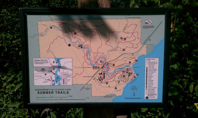
Gooseberry Falls is extremely popular with the North Shore Tourist Crowd. I should know, I used to be one of them. But now I'm a local and have been spoiled by the sweet, sweet solitude in the parks during the off-season. Thunderdog and I entered the park to find people everywhere. Don't get me wrong, it's awesome that people come to visit. Outdoors = yay! Stimulating local economy = yay! I just wanted a bit of solitude, and wasn't sure if I'd find it at Gooseberry. Thunderdog and I consulted a park map, and found what we hoped was a solution.
 |
| Map o' the park |
If you look closely at the map, you'll see that there is a long loop on the left-hand side - leading away from the waterfalls and the cluster of trails on the right. Now THAT looks like a nice, secluded trail. 4 miles long if you count the "stem" to and from the visitor center, .3 miles of the Superior Hiking Trail. And then there's the mystery aspect: part of the trail is hidden behind the inset map. What's back there? A mountain? A pit of vipers? What is the inset map hiding??? Well, we were going to find out!
 |
| Thunderdog surveys the path |
In general, it was a wide, grassy path with lots of deciduous trees on either side. It was mainly flat, but had some impressive hills. When we reached the top of the largest hill, I discovered that my "steep paths lead to good lookouts" adage is not always right. We merely found ourselves amongst a cluster of trees, at the top of the hill. We covered a mere .3 miles of the Superior Hiking Trail by the Fifth Falls Bridge (we saw the other side of the bridge back on June 5th), but hey! It counts.
 |
| Thunderdog found time to enjoy chewing on a stick. |
Once down off of the view-less hill, the trail took us along the Gooseberry river. It was interesting to see evidence of the flood, which occurred about a month ago. If you look at the picture below, you'll see weeds and other debris curled around the trunk and branches of the trees. The tree in the center of the picture has weeds wrapped around it about six feet off of the ground. The river, safely back in its banks, is now about 20 feet away.
 |
| Debris in the Trees |
We were hiking down the path, minding our own business, when we discovered what was hidden behind the inset map: a giant woodchuck!! I didn't even see it on the path until it came flying at Thunderdog, a blur of fur and gnashing teeth and claws. It got right up in Thunderdog's face - I'm not sure if it actually touched her, but to Thunderdog's credit she backed up and just barked at it. Do not engage the crazy woodland creature!
 |
| GET OFF MY TRAIL |
Every time we tried to move forward on the trail, the woodchuck would run onto it and resume its Tasmanian Devil routine. I shouted at it and threw a stick at it, hoping that it would go back into the forest so that we could pass. Thunderdog was beginning to work herself into a tizzy, barking and lunging. Finally, we just had to turn around and walk to the last fork in the trail. I felt kind of stupid. Waylaid by a rodent!
Anyway, we had a fine walk in the woods. Woodchuck aside, we found the solitude we were looking for. I'm glad there are still places in the North Shore parks that one can retreat to on a warm summer's day.
Total miles hiked today: 4 (.3 of the SHT)
Total miles hiked (in 2012): 83.9
Total ticks today: Joe - 0; Thunderdog - 0; Elly - 1
Total ticks (in 2012): 47
No comments:
Post a Comment